The Moolap Coastal Strategic Framework Plan (Moolap Plan) is the Victorian State Government’s vision for northern Moolap including Point Henry, the former saltworks, industrial and adjacent rural areas.
The study area is undergoing change and the Moolap Plan provides a strategic framework to guide this change for the next 100 years.
The Moolap Plan itself does not approve development or rezone land.
Implementation will be undertaken over time, informed by the future actions of Government and land owners.
The Plan
The Moolap Coastal Strategic Framework Plan was prepared by the Department of Environment, Land, Water and Planning (DELWP) in consultation across government and the Geelong Authority.
The Moolap Plan has considered site attributes, relevant policy and the range of feedback received during three rounds of community and stakeholder engagement.
For more information see Background and research as well as Engagement and feedback.
On Friday 23 August 2019, the Moolap Plan was released by Lisa Neville MP, Member for Bellarine representing both the Minister for Energy, Environment and Climate Change (Lily D’Ambrosio) and the Minister of Planning (Richard Wynne).
The closure of Alcoa Australia's Point Henry operations in 2014 and a proposal for the former salt works were key drivers for the preparation of the Moolap Plan.
The study area of northern Moolap and Point Henry provides an unparalleled opportunity for urban renewal and environmental protection on the doorstep of Geelong.
The Moolap Plan creates the appropriate setting for something new and unique that celebrates Geelong, its environment, its location and its history.
Implementation is required for the Moolap Plan to start making an impact and influence decisions. Informed by the future actions of Government and land owners, implementation of the Moolap Plan will be undertaken over time.
As described in the Moolap Plan, the implementation steps include:
- Policy implementation
- Management of the Wetlands and Former Saltworks Precinct
- Realising land use transition (including interim uses)
- Detailed planning to guide urban development
- Infrastructure assets analysis
- Management of the foreshore
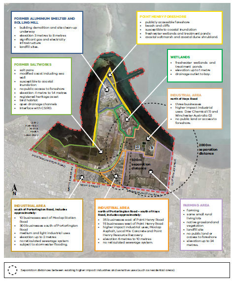
The study area is approximately 5 kilometres east of central Geelong's business district and includes over 1,200 hectares of land and 10 km of coastline.
The site attributes have a key role in informing the future possibilities for the study area, including its unique location and history, together with environmental values, risks and constraints.
The study area for the Moolap Plan includes:
- The former Alcoa aluminium smelter site and rolling mill at Point Henry at the north end of the Point Henry peninsula
- Other freehold land also owned by Alcoa Australia including wetlands, farming land and re-vegetated sites
- The Point Henry Pier owned by Geelong Port
- The former Cheetham Salt works (part Crown land leased and part land owned by Ridley Corporation)
- Crown coastal foreshore land and coastal waters
- The Moolap Industrial Estate (south of Portarlington Road)
- The Moolap industrial precinct, generally east of Point Henry Road, including Dow Chemical and Winchester.
Page last updated: 25/08/21